Today me and Scipio finally made it to the actual state park portion of Cheaha State Park, which is located on and around Mt. Cheaha, Alabama's Highest Point, which is itself located within Talladega National Forest.
Here is a picture of Mt. Cheaha from a few miles away, from AFTER we were up there. It turned out that the road to High Falls (small waterfall nearby) is STILL closed, and I wasn't up to the 45-minute detour that would have been required to check the water levels after today's rain...
http://www.szulecki.com/images/IMG_6290
Mt. Cheaha is 2,407ft ASL, but feels about twice that due to the very low elevation of the surrounding terrain facing west, which is all you can see from the boardwalked Bald Rock overlook. Cheaha is in a chain that makes up the very last of the Appalachians, and that chain is also the only portion of the Blue Ridge that extends into Alabama. The rest of Alabama's high elevations are related to the Cumberland Plateau.
Here is an image showing that there is a boardwalk...
http://www.szulecki.com/images/IMG_6287
To illustrate how high the mountain is in comparison to the surrounding terrain, that tiny cut in the woods is the road to the mountain.
http://www.szulecki.com/images/IMG_6286
There are Bonsai like trees growing all over the top of the mountain, which gets battered pretty hard by the wind and weather, especially in the winter. This little tree is seen in some popular local photographer's sunset shots. I think that was prior to the developments in the background...
http://www.szulecki.com/images/IMG_6289
I tried to make a panoramic image, but the program (Autostitch - freeware) smeared it a bit. Here is the panoramic and the originals...
http://www.szulecki.com/images/IMG_6281
http://www.szulecki.com/images/IMG_6282
http://www.szulecki.com/images/IMG_6284
http://www.szulecki.com/images/pano
I'm pretty sure that cleared mountain to the left in the last image is (C?)Old Water Mountain/Cold Water Peak, just outside of Anniston, AL. It is really the only high point in that direction for quite a ways. It is around 1700ft ASL.
Alabama's portion of the Blue Ridge mountains runs from the Georgia border near Tecumseh, AL to around Hollins, AL. Alabama has the last 2000ft+ peak and that last 1000ft+ peak in the whole Appalachians, which end right southerly around Hollins with the end of the Blue Ridge. There are a few named peaks above 2000ft in Alabama, with some clustered around Cheaha 10-15 miles south of Anniston, and some clustered north east of Anniston around Dugger Mountain, Alabama's second highest peak.
It was interesting, if photographically disappointing due to the time of day and weather. It was a pretty nice day, just to sunny for my tastes. This would be a GREAT spot to watch incoming thunderstorms, if you are willing to risk the shock...
Friday, October 19, 2007
Saturday, October 6, 2007
Sipsey Wilderness and Winston County 10/6/07
I finally managed to get out to Sipsey for the first time in two years today. The weather was beautiful for being at the beach, but terrible for waterfall photography. The drive is around 1.5-2 hours from my apartment here in Birmingham to the Sipsey Wilderness. I started by checking how crowded the "trailhead" for Caney Creek Falls was, which was where I really wanted to go, but seeing how much foliage was covering the old logging road that forms about 1/2 mile of the 3/4 mile hile, I decided the trail to the falls (the last 1/4 mile) was probably to overgrown to take this little guy through before fall...


There was still a little bit of interesting plant life in bloom or fruiting in the area. Most of the creeks and streams in Sipsey have massive wildflower blooms along their floodplains every spring. If you can call a canyon a floodplain...


This may be the last time I use blogger for one of my adventure posts. I'll probably just go back to putting them on my site. I don't like the way blogger handles pictures.

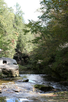
I decided to check out Kinlock Falls, which I have listed and pictured on my website, but have never personally visited. Kinlock Falls, due to its close proximity to the road (less than 500ft, but steep), gentle slope, and deep pool is a popular swimming spot. There were many signs of human activity here, beer cans, shoes, cloths, panties, yet thankfully, no signs of human reproduction... The site was once home to a mill, hence the square hole in the rock in this picture.

After following the creek from the bridge to the top of the falls (I missed the easy way down), I was presented with the challenge of finding a route around the top of the falls. Luckily, this area is well visited and I quickly found a well worn path.

I wish the lighting had been better, and I had remembered my tripod, which was resting uselessly in my trunk, about 500ft away, but about 100ft above me... This waterfall type is one of the best for fall waterfall photography, because the relatively shallow slope allows for leaves to accumulate in the non-flowing portions of the slope. It looks really good if the leaf color and lighting are just right.

I only managed one long-exposure shot of the waterfall, accomplished by placing it on my backpack, and running the self-timer. I'm disappointed.

There was still a little bit of interesting plant life in bloom or fruiting in the area. Most of the creeks and streams in Sipsey have massive wildflower blooms along their floodplains every spring. If you can call a canyon a floodplain...


On my way home, I couldn't resist getting a picture of this local landmark. If you've never heard of the Free State of Winston/Republic of Winston, or think that all the South supported the Confederacy, you might want to read a little about it... http://en.wikipedia.org/wiki/Republic_of_Winston

Subscribe to:
Posts (Atom)